The quick answer here is, yes. Although many hikers rely on their smartphones as an emergency device and source of information (more on that later), a GPS is the most reliable way to stay safe, stay connected, and stay on track when backpacking.
This also still applies to small hikes. A small hike might still take an unexpected turn, and it’s always better to be overprepared than underprepared when in nature, especially if you’re going it alone.
Think about this scenario: You are part way through your hike and can either continue or turn back and/or make your camp. There are several things to consider: how much further to the end of the trail, what the terrain is like, what the weather will be like in a few hours.
All of this information you can get from a GPS device. When out in nature, the more information you have about your surroundings, the better informed your decisions will be. A GPS device is your best decision-maker.
Below I break down what a GPS is, how it helps, and why you need it.
What is GPS for Backpackers
GPS stands for Global Positioning System. Created by the US government, a GPS unit pulls information off of a series of satellites. This information is then transmitted to GPS devices.
Think of it like a compass that can map your location and remember your route. What’s great about a GPS receiver is that it doesn’t need any telephone lines or internet connections to work. If you can get a signal off a satellite, then you can find your exact positioning on the planet.
As mentioned above about the need for GPS even doing short day hikes; they are even more dangerous. This National Geographic article is about day hikers being the most vulnerable if you want to read more.
All the Ways a GPS Helps on a Hike
Portable GPS tracking devices come with a variety of functions, all of them useful when backpacking in the wilderness. Here are just a few:
-
Get Your Bearings – See, in the “old days,” hikers would know the time and direction based on the position of the sun, or the use of a compass. Luckily for us, we now have the technology to assist. A GPS can help you find landmarks and will notify you when you veer off course.
-
Avoid Getting Lost – Speaking of veering off course, if this happens, you can use your GPS device to determine exactly where you are in regards to the trail. You can retrace your steps to get back on track, or if you are too far off, the device can map a new route for you.
-
Check Topography Maps – Think of these like 3D maps, where you can view the terrain with shading that makes it pop. Topo maps are very useful if you’re in hilly or mountainous terrain, as more often than not elevation changes are deceiving from a distance.
You can also look for landmarks that are pre-loaded, or make your own waypoints, which is like adding your own feature or point of interest to a map.
-
Plan Your Route – Although you should be planning your route before you set out, sometimes you need to make last-minute changes. A GPS will have downloaded maps so that you can change your route as you go, based on distance and terrain. Also, if you’re part of a group that doesn’t stay together, you can share route information when separated.
-
Keep Track of Your Hike – A GPS not only guides you where to go, but it can get you back again. You can also track your distance walked, distance left to walk, and even add in information like average speed, elevation changes, and incline.
-
Weather – Since your device is pulling information off several satellites, you can get data about weather, and not just the weather where you currently are, also what it’s like ahead and in the coming hours.
-
Accurate positioning if you need help – If something goes wrong during your trek, then you need an accurate position. This is the benefit of a GPS as you will get your exact coordinates that you can then communicate to others, either through your phone or on a two-way satellite communicator.
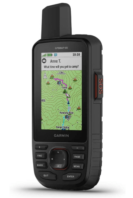
Some GPS units have communicators included. I like the Garmin GPSMAP 66i because it ticks all the boxes we went over. Check to see if it’s still available on Amazon here.

This Garmin GPSMAP 66i does everything mentioned above
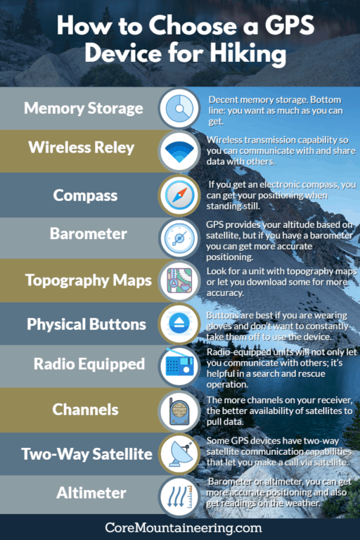
How to Choose a GPS Device for Hiking
Portable GPS devices have become more popular of late, so you’ll definitely have your choice. Here are some features to look for:
-
Decent memory storage. Bottom line: you want as much as you can get.
-
Wireless transmission capability so you can communicate with compatible units and share data with others.
-
Compass. All GPS units will have a compass to tell you your positioning when moving, but if you get an electronic compass, you can get your positioning when standing still.
-
Barometer/altimeter. Your GPS can provide your altitude based on satellite data, but if you have a barometer or altimeter, you can get more accurate positioning and also get readings on the weather.
-
Maps. Your unit will have basic map data but look for devices that either has topography maps or let you download some for more accuracy.
-
Buttons vs. swipe screen. Buttons are best if you are wearing gloves and don’t want to constantly take them off to use the device. These North Face gloves allow you to keep them on while working with a touch screen. Check them out on Amazon here.
-
Radio equipped devices will not only let you communicate with others, but it’s helpful if there’s a search and rescue operation.
-
A number of channels. The more channels on your receiver, the better availability of satellites to pull data for your location.
-
Communication. Some GPS devices have two-way satellite communication capabilities that will let you make a call via satellite vs. cell service. Research these thoroughly, however, as not all locations allow for satellite communications and those that do might charge a hefty fee. It might be more practical to get a device with an SOS button.
All of this said, Garmin has the largest variety of handheld GPS units available on Amazon, consider the Garmin GPSMAP 64x for a variety of features. The SPOT Gen 3 also available on Amazon is an alternative that will give you satellite messaging and tracking.
Now, even though most units have similar features, each device will have specific operating instructions, making it difficult to give a one-size-fits-all guide. Make sure you study the operating manual of your device and practice before you use it in the wild.
Learn How to Read Coordinates
So, you have your GPS unit, but do you know how to read it? GPS gives your positioning based on coordinates: longitude and latitude lines. If you’re like me and vaguely remember that lesson from school, then you’ll need to brush up on how to read these lines.
For a refresher:
latitude lines are the horizontal lines that circle the earth and they count up (N) and down (S) from the equator. These lines are intersected by longitude lines that run from pole to pole and move east or west of the Prime Meridian.
Satellites will map your position based on these lines and give you a long string of numbers and degree signs. Once you know what all these numbers mean, understanding your location will be easy.
Can I Just Use My Smartphone
Yes, you technically can use your phone. Many phones have GPS tech from available apps. However, a phone is not meant to withstand outdoor elements or any rugged use.
You still need cell service for most of your phone gadgets to work.
Then there’s the juice that’s required to run your phone. To use the GPS app, you’re constantly getting a signal from satellites and local cell towers, not to mention the data being used for the app to run. All of this will quickly drain your battery.
Don’t Go, It Alone
It can seem exciting to go trekking through the wilderness completely cut off from the modern world. I know plenty of backpackers who go to escape their phones and clear their thoughts. However, that doesn’t mean you should hike without any way to communicate with others, no matter your skill level.
A GPS unit is great to have. Even if you don’t use it all the time, knowing it is there in your pack is like knowing you have a fail-safe if there is an emergency. Why not have that failsafe?
Despite all of this, don’t just assume you’re completely cared for with your portable GPS. Technology can fail, no matter how strong it is.
It’s always good to take a physical map with you and know how to read it. The same goes for a real compass. These things don’t rely on charged batteries or satellite positioning. Always have a backup to your tech. It just might save you one day.